


Choose park
Check in
Check out
Guests
Check in/out
Guests
Search
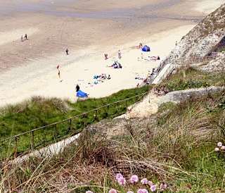
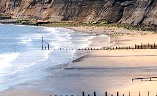
There are so many amazing coastal walks on the Isle of Wight. With coastal walks, you can easily explore the whole of the island in multiple days — a perfect activity for your next Isle of Wight holiday!


Explore the 70-mile Isle of Wight Coastal Path, split into six sections, offering breathtaking scenery from Cowes to Yarmouth, Brighstone, Niton, Sandown, Ryde, and back.
Discover iconic landmarks like The Needles, Tennyson Down, and Shanklin Chine along some of the most scenic coastal walks in the Isle of Wight.
Enjoy shorter, family-friendly or dog-friendly routes such as Estuary Newton Walk, Tip of the Wight Walk, and St Helens Duver, perfect for a relaxing day outdoors.
Immerse yourself in both natural beauty and history with trails featuring ancient monuments, Victorian promenades, and historic abbeys.
Use Isle of Wight holiday parks as convenient bases, allowing easy access to coastal walks while providing comfort and amenities to recharge after your adventures.
Shortest walks: Mottistone Gardens to Sudmoor Point (2.8 miles, easy), Tip of the Wight walk (3.5 miles, moderate), and Estuary Newton Walk (3.6 miles, easy) are the best options if you only have a few hours.
Dog-friendly routes: most walks on this list are suitable for dogs on leads, including the Tennyson Down Trail, Compton Bay walk, St Helens Duver, and all six sections of the main coastal path.
Planning a multi-day itinerary: the coastal path splits naturally into six sections of 8–17 miles each. Stay at Whitecliff Bay or St Helens holiday park to access the Sandown-to-Ryde and Bembridge sections without driving.
Imagine waking up to stunning beaches, charming villages, and incredible attractions just a stroll away! Take a look at our Isle of Wight holiday homes for sale and see how your dream getaway could become your everyday reality.
Whether you want to tackle the Isle of Wight coastal path or explore St Helens Duver, you're in for a treat! We'll take you through the island's coastal path and show you the steps of other amazing walks.
What makes this even better is that you can use some of the best Isle of Wight holiday parks as a base for your explorations to re-energise and prepare for each walk. No matter who you're holidaying with, you can find a walking holiday to suit your needs, so let's get into it!
All 13 walks in this guide are accessible from the ferry terminals at Yarmouth, Cowes, or Ryde with no car required, though most trailheads have parking if you're driving. Dogs are welcome on the majority of routes, and seven of the thirteen can be completed in under two hours.
The Isle of Wight Coastal Path can be divided into six distinct sections, each with its unique features. These make for some of the best coastal walks in the Isle of Wight.
You can easily access the coastal path from your ferry or hovercraft terminal if you arrive on the island via Yarmouth, Cowes, or Ryde.
As the Isle of Wight, coastal path covers 70 miles and generally takes about six days to complete, many walkers choose to split the route across several days, especially as you can then plan your accommodation choices.
Most walkers cover 10–15 miles per day. The path is waymarked throughout and can be joined or left at multiple points, so you don't need to walk it in order or complete it in one trip.
The entire Isle of Wight Coastal Path offers breathtaking scenery, ensuring an enjoyable journey. Let's delve into the different spots along the way!
|
Section |
Distance |
Time (approx) |
Difficulty |
|
Cowes to Yarmouth |
17.4 miles |
6-7 hours |
Moderate |
|
Yarmouth to Brighstone |
13.4 miles |
5-6 hours |
Moderate |
|
Brighstone to Niton |
8 miles |
3-4 hours |
Moderate |
|
Niton to Sandown |
10.7 miles |
4-5 hours |
Moderate |
|
Sandown to Ryde |
12.2 miles |
5 hours |
Moderate |
|
Ryde to Cowes |
7.7miles |
3 hours |
Moderate |

This part of the Isle of Wight coastal path allows you to wander through the Newton Nature Reserve. Taking you from the yacht haven of Cowes to the historic port of Yarmouth, you'll pass through villages, woodlands, and clifftops. Here, you'll catch some stunning views over the Solent to the mainland and the Newton River estuary.
Length: 17.4 miles Difficulty: Moderate
Find out more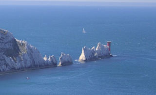
The second section of this path will reward you with some of the best coastal views in England and one of the most impressive coastal walks on the Isle of Wight. Along the way, some of the most unique parts include Alum Bay with its multicoloured cliffs, the iconic Needles landmark, and panoramic views from West High and Tennyson Down.
Length: 13.4 miles Difficulty: Moderate
Find out more
Along the island's south coast, you can take in Shanklin Chine, a series of dramatic gorges that are another iconic feature of the Isle of Wight. You can avoid the crowds with this walk and come across Atherfield Beach, one of the most beautiful and secluded beaches in the UK.
Length: 8 miles Difficulty: Moderate
Find out more
This relatively straightforward coastal walk takes you to Ventnor. While in Ventnor, you may want to stop off at the Ventnor Botanic Garden, perfect for nature enthusiasts. Along one of the best coastal walks in the Isle of Wight, you'll also come across the Victorian promenades next to the sandy beaches at Shanklin and Sandown.
Length: 10.7 miles Difficulty: Moderate
Find out more
Sandown is a popular destination for holiday-goers and avid walkers, making it the perfect starting location for this section of the path! You'll pass through some stunning wildlife, and the nearby Brading Marshes RSPB reserve. Along this coastal walk on the island, you'll reach Yaverland, the site of the Isle of Wight Zoo.
Length: 12.2 miles Difficulty: Moderate
Find out more
This walk takes you away from the coast itself to explore a ruined abbey, a previous royal residence, and a vineyard. Starting from the pier in Ryde, you'll wind your way westwards out of town, where you'll get to Quarr Abbey. Continue towards Cowes, where you can stop off at Osbourne House to end the Isle of Wight coastal path!
Length: 7.7 miles Difficulty: Moderate
Find out moreHere are some other trails to try! If you've completed the Isle of Wight coastal path (well done!), you may be looking for other paths to tackle. Here are some other coastal walks in the Isle of Wight that may be more suitable for you.
We'll take you through each step so you're best equipped to start your walking journey while on holiday!
Short on time? The Mottistone to Sudmoor Point walk (2.8 miles) and Tip of the Wight walk (3.5 miles) can both be completed in under two hours. Looking for a challenge after the coastal path? The Bembridge and Culver Downs Trail and St Helens Duver both have sections rated challenging.

Tennyson Down trail is a must-visit for nature lovers, history enthusiasts, and anyone looking to experience the charm of the Isle of Wight's coastal scenery. The combination of panoramic views, cultural landmarks, and natural beauty makes this trail a memorable excursion for visitors. The Tennyson Monument is striking stone cross in memory of the famous poet Alfred Lord Tennyson
Find out moreBest for: views of The Needles, photography, and literary history. The short trail (3 miles) is suitable for families; the full 7-mile route is more demanding. Dogs welcome on lead.
Facing the quarry, take the left-hand path from the car park. After 45 yards, turn right and climb the steps by a wooden bench, following the T27 signpost. The steep upward path continues through a kissing gate to the top of the hill.
At the Tennyson Monument, turn right and follow any clifftop paths towards the aerial mast to the far west. Cross one stile and a gate, then skirt the right boundary of the aerial building and head diagonally left and downwards to a concrete road near the Coastguard Station. Cross over and follow the signs to the Needles viewpoint.
Return to the road, turn left, and climb the steps beyond the Coastguard Station. Follow the path down to the Needles Old Battery, then the tarmac road towards Alum Bay. Where the road bends left towards Needles Park, go straight ahead, signposted T25, and climb through a kissing gate. Along the lower boundary of the slope, pass the farm until it starts to rise. Follow the track diagonally upwards to a beacon, then take the rutted path T24 gently downhill on the left, returning to the car park.
For a longer walk, follow the outward track from the car park but go straight, following the signposted footpath T24 instead of turning right. Pass through a bridle gate and follow the path at the bottom edge of the trees. Turn 90 degrees left through a gate and down the bridleway at a four-way junction. Turn right at the T-junction and go along the path, with a golf course and glimpses of Farringford on the left.
At the gate onto the road, turn right towards Freshwater Bay, and pass the thatched church of St Agnes. Carry on and turn right through a gate into a field. Go straight up the hill, through the gate on the skyline. Bear right and carry on uphill until the Tennyson Monument is reached. Turn right and head to the gap in the trees, retracing your steps down the steep path back to the car park.

The Compton Bay and Downs walk offers a wonderful opportunity to immerse yourself in the natural beauty of the Isle of Wight's coastline and countryside. Whether you're seeking a leisurely beach walk or a more adventurous hike, this route showcases the island's diverse landscapes and scenic highlights.
Find out moreBest for: beach walkers and those combining a hike with a swim. Compton Bay is one of the best surf beaches on the island and is accessible mid-route. Dogs welcome.
Take the track uphill, part of the Tennyson Trail, and follow the ridges over the downs. Follow the trail for 2.5 miles, going through one gate. After a bench, take a detour left to reach the Five Barrows and trig point, rejoin the track and head downwards to a road.
Turn right on the road, then left up a tarmac drive on footpath S39. Where the drive swings right, go through a kissing gate. 15 yards before the next gate, turn right into private woodland, following the path down through a kissing gate into a field. Continue over two more stiles to reach the road at Hulverstone.
Turn left and walk for 45 yards, then right along the lane. After 65 yards, step over a wall on your right, signed BS47 Brook, heading for the sea. Follow the path over five stiles, passing a pond. Join a track and follow it into Brook Village. Turn left at the road and continue to the junction with the Military Road. Cross over, then turn right and follow the clear path to the National Trust car park.
From Brook car park, take the coast path on the far side. If the tide is low, go left down the path and a concrete ramp onto the beach. Follow the coast around the headland and climb the steps to Shippards Chine to rejoin the coast path.
Follow the coast path to Compton Chine, going left of the fence, over a stile and footbridge. Meet the road after some steps and a stile. The path continues left of the road, bending coastward after the crest. Then, bear right to return to the car park.
Length: 7.5 miles
Difficulty: Moderate
The Tip of the Wight walk is a memorable way to explore the rugged beauty and coastal charm of the Isle of Wight's southernmost region. Whether you're a seasoned hiker or simply seeking a leisurely stroll with breathtaking views, this coastal route promises an unforgettable experience of England's southern coastline.
Find out moreBest for: a short half-day walk with genuine coastal drama. At 3.5 miles, it's one of the most manageable routes on this list. The Freshwater Cliffs car park is roughly 10 minutes from The Bay Colwell holiday park.
At the Freshwater Cliffs car park, about a 10-minute drive from The Bay Colwell holiday park, go through the furthest kissing gate and turn left along a grassy track, bearing down into a dip. Turn left and follow the path through the valley, then bear right and gently uphill at the fork. At the junction, turn left parallel to the coast, keeping right of the large rock and eventually dropping down to a road.
Bear right up the drive to Knowles Farm. Pass in front and go through the kissing gate to the left of the field gate. Continue straight for 220 yards, then bear left and follow the cliff edge path back to the lighthouse, crossing a stile below the farm. Turn left at the white boundary wall and follow it to a gate. Go through, cross the road, and over the ladder stile.
Follow the lighthouse boundary, cross another ladder stile, and turn right to return to the cliff top. Continue along the coast via a kissing gate. Pass through and turn left on the stony track, with a short detour to the secluded cove on the right.
Climb the track, then 100 yards after a sharp right bend, turn left up a tarmac path with steps. Emerge onto a road, turn right for 45 yards, then left up a tarmac path by the phone box. Turn right onto another road, forking right at the Y-junction. Cross the main road to a grassy area and follow the footpath on the right up Barrack Shute.
Before the crest, take the left turn signed 'Coastal Path' upwards to a kissing gate. Follow the grassy coast path along the cliffs. Then, turn left at the marker post just before a seat and descend the steep, sometimes exposed path with steps to the road. Turn right and follow it back to the car park.

The Mottistone Gardens to Sudmoor Point walk offers a wonderful blend of coastal exploration, countryside vistas, and historical discovery on the Isle of Wight. It's a great way to experience the diverse landscapes and natural beauty of this scenic part of the island.
Find out moreBest for: families and first-time walkers. At 2.8 miles on largely flat terrain, this is the easiest walk in this guide and passes a National Trust garden en route.
Go down the steps from the Mottistone Gardens National Trust car park towards Mottistone Gardens. Cross the road and enter the churchyard by the lych gate. Leave by the south gate, turn right into Ridget Lane, and follow it for 80 yards.
Turn right along the track signposted BS74 towards the farm, but take the stile on the left just before the farm to continue on BS74. When the track opens out, bear left and follow the boundary, keeping the trees to the left.
Turn right at the T-junction where a hedgerow crosses. Bear left before the trees, keeping the wood and a small stream on the right. At the end of the wood, the path goes towards the right, over a plank bridge and stile. Follow the path across the meadow. Cross the stile at the end of the field and turn left through a farm gate onto the Military Road.
Turn right on the road and walk along the right-hand verge. After two cottages, cross the road and go over a stile onto a permissive path. The path crosses a wooden footbridge, then follows the field edge with hedges on the left to a stile in the corner. Cross the stile and the following field, keeping close to the fence on the left until reaching the cliffs.
Turn left onto the coast path. Follow the clifftop path, passing through a kissing gate near an eroded section. At the 'Public Footpath' sign, go through the kissing gate on the left and follow the field edge to another gate. Cross the Military Road to join the byway BS100, a hedge-lined farm track leading back to Mottistone. At the top, bear right and then left past the church to reach the road and the car park entrance.

The Estuary Newton walk is a relaxing and scenic way to explore the natural beauty and coastal charm of the Isle of Wight's northwestern region. Whether you're a casual walker or a nature enthusiast, this route offers a mix of landscapes, wildlife, and historical interest for an enjoyable day out.
Find out moreBest for: birdwatchers and nature lovers. The Newton National Nature Reserve is one of the island's best wildlife sites, with two bird hides along the route. Dogs on leads are welcome.
From the Newton National Reserve car park entrance, turn right and follow the road down the hill past the Old Town Hall. Take the signed CB16a footpath on the right, just before Cassey Bridge. Follow the hedge line, go through a gate, and continue across two fields. Go through another gate and along the gravel track to a road. Walk straight ahead, then turn right down a gravel track by the farmhouse to the Mercia Seabroke Bird Hide.
Turn left through a gate and cross to the opposite corner of the field, then turn right onto the footbridge to the boathouse. Bear left, following the gravelled harbour wall round to reach a kissing gate. Follow the right-hand boundary of the field to a gate and the gravel path to the road.
Follow the tarmac road to a T-junction by the visitor point, then cross straight over and take the grassy footpath (signed Coastal path and CB13a) through the gate to the left of Noah's Ark. This path bends right, then left after 20 yards across a field to a gate. Go straight across a second field and through a gap in the hedge into another field to reach a gate by the road.
After 220 yards, enter Walters Copse on the left. At a junction, bend left on the main track, then take a right track straight to the copse edge. Turn left and follow the boundary path. Keep close to the copse at the junction, but not into the marsh. At Town Quay, a sign warns that path CB9 leads only to the bird hide. For a 600-yard detour, go through the kissing gate and keep to the right of the field to visit East Bird Hide.
Take the broad track heading away from Town Quay through Town Copse, eventually reaching the road. Turn right and follow the road back to the visitor point.

Whether you're interested in wildlife, coastal scenery, or simply relaxing by the sea, St Helens Duver provides a tranquil escape on the Isle of Wight. It's a delightful spot to reconnect with nature and enjoy the island's natural beauty.
Find out moreBest for: a relaxed coastal stroll with views across Bembridge Harbour. The route is tide-dependent — the low-tide beach version is the more scenic option. Dogs welcome.
Leave the St Helens Duver National Trust car park by following the hedge to the left and go up the sandy path by the green dog bin. Cross the grass and road, aiming for the boats in Bembridge Harbour. Turn left along the embankment path, cross the road, and take the grassy path on the right. Follow a track between the houses onto the promenade. Turn left and walk to the remains of St Helens Old Church. Past the church, continue to the interpretation panel and National Trust sign for Node's Point – go onto the sands here.
If it's low tide, walk along the sands for about a mile, passing through three rocky headlands. After Horestone Point, take the raised boardwalk along the back of Seagrove Bay.
If it's high tide, backtrack to the road by St Helens Old Church, turn right, and follow it for 110 yards. Take the signed coastal path through a memorial gate up the right edge of the field. Cross a bridge through another gate, then diagonally up the next field to a metal kissing gate. Turn right along the road, bearing left at the caravan park entrance.
If low tide, walk along the promenade, then take the road left up Ferniclose Road, footpath R74, climbing to a gate/stile. Go through this and continue straight, keeping a hedge on your left. Go through a field gate and follow the directions until you reach a road via a memorial gate. Turn right for 25 yards, then left along footpath R82 to St Helens. Bending left by the school, cross a cul-de-sac and follow a path between houses. Turn left along the pavement back to the Duver, noticing the plaque to Sophie Dawes. Turn right into Duver Road.
Just before some traffic lights, turn right onto a path through St Helens Common. Go down this path, cross a wooden footbridge, and continue diagonally left across the grassy area back to the car park.
The Bembridge and Culver Downs trail is a rewarding walk that showcases the natural beauty and coastal heritage of the Isle of Wight's eastern coastline. Whether you're interested in hiking, wildlife spotting, or simply enjoying scenic views, this trail offers a memorable outdoor experience on the island.
Find out moreBest for: views and a sense of isolation. Culver Down offers some of the most dramatic panoramas on the island's east coast. The windmill at the start is one of the oldest on the island.
From the Bembridge Windmill lay-by, walk to the bend in the road and turn left to Bembridge Windmill. Go downhill to Steyne Wood, and before the interpretation panel, bear left to follow a path that reaches a road. Cross over, go through a gate, and continue on path BB22 up a gentle rise past a caravan park to Hillway Road. Turn left up the road, then take the first right after 100 yards into Jenny Street's Lane. Follow the path signposted BB15, eventually meeting the coastal path.
Turn right and walk along the coastal path with views of Whitecliff Bay. Pass BB16, then bear right of the seats and cross the concrete ramp, keeping right of the hedge and passing over a wooden bridge. Go through a kissing gate and follow the path diagonally up the hillside, turning left at the hedge to pass through another gate to an interpretation panel. After 30 yards, bear right, cross the car park, and go up steep concrete steps to the beacon.
From the beacon, turn right and follow the road past the pub and Yarborough Monument. Turn left immediately after the café and follow the signed coastal path for 380 yards to a line of scrub. Bear right along the upper edge, keeping the bushes on your left. Continue through a hedge gap and then turn right, heading upwards and emerging onto the road near Bembridge Fort.
Take the grassy downhill path opposite the fort entrance for 50 yards, then bear diagonally left and downwards along the track, continuing through a break in the hedgerow. Take the first right and head down the valley, descending all the time, to pass through a kissing gate to the busy road.
Follow the road to the right for 40 yards, then take the left BB31 footpath. Bear right and follow the hedge, turning into the wood at a kissing gate, then after 20 yards, turn left to the Eastern Yar sluice gate.
Retrace your steps, bearing left at the path junction into Centurion's Copse. Cross the middle of the field by the oak tree, over the next field, and through a kissing gate onto Bembridge Airfield runway. Follow the edge of Brading Haven reserve to the top corner of a field. Bear right over a stile and return to Bembridge Windmill. Turn left to get back to the lay-by.
There are so many great walks, but here are some of the best coastal paths in the Isle of Wight that you just have to add to your holiday plans:
The Isle of Wight coastal path
Estuary Newton Walk
Tip of the Wight walk
Headon Warren walk
Compton Bay and Downs walk
Tennyson Town trail
Bembridge and Culver Downs trail
The full 70-mile route takes most walkers five to seven days, covering 10–15 miles per day. The shortest single section is Brighstone to Niton at 8 miles (roughly 3–4 hours), making it a good introduction if you're new to the route.
Dogs are welcome on leads across the vast majority of routes in this guide, including all six sections of the main coastal path, the Tennyson Down Trail, Compton Bay and Downs Walk, Estuary Newton Walk, and St Helens Duver. Some sections pass through farmland where dogs must remain on leads around livestock. The Mottistone Gardens section passes through a National Trust garden where dog access may be restricted, check ahead.
The Mottistone Gardens to Sudmoor Point walk (2.8 miles, rated easy) is the most accessible route in this guide, with largely flat terrain and a short total distance. The Estuary Newton Walk (3.6 miles, easy) and Tip of the Wight Walk (3.5 miles, moderate) are also manageable for families or those looking for a shorter outing. Both can be completed in two hours or less at a comfortable pace.
The Yarmouth to Brighstone section of the main coastal path offers the closest walking access to The Needles, passing through Alum Bay with its multicoloured cliffs and reaching a dedicated viewpoint near the Needles Old Battery. The Tennyson Down Trail also offers panoramic views of The Needles from the ridge.
After picking one of these best walks to try, why not book your next Isle of Wight holiday so you can see for yourself why they are so loved?
Check out our guide about everything you need to know about taking the ferry to the Isle of Wight.
Hampshire | Scotland | Isle of Wight | Dorset | North Wales | Yorkshire | Lincolnshire | Cornwall
Kate has been part of Away Resorts for many years, beginning her journey as a Holiday Home Advisor at Whitecliff Bay Holiday Park. She’s passionate about sharing authentic experiences that show what makes Away Resorts so special, whether that’s alpaca walks, surfing on the FlowRider, or simply enjoying time together in beautiful locations. Outside of work, Kate loves spending time by the coast and countryside. Her favourite spots include the beaches at St Ives Bay, wandering around Padstow, and exploring the stunning New Forest countryside around Sandy Balls Holiday Village.
Follow Kate Watts for thoughtful takes, fresh ideas, and inspiring reads.
Whilst you wait... just think about being in your swimmers, the sun's out and the smiles are big
Enter your details to make a payment or request a change
Don't remember your details? Check your confirmation email, or speak to our team
Are you an owner with us? Click here to login