


Choose park
Check in
Check out
Guests
Check in/out
Guests
Search
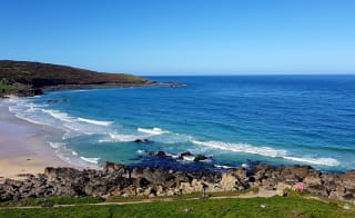
St Ives is a truly special coastal town, surrounded by stunning golden, sandy beaches on three sides and features a headland with breathtaking views out over the bay.


Discover St Ives’ breathtaking coastal walks, including routes to Zennor, Penzance, Carbis Bay, and Trencrom Hill.
Explore family-friendly and dog-friendly walks along St Ives Bay, perfect for all ages and abilities.
Experience the South West Coast Path from St Ives, offering a mix of easy, moderate, and challenging trails.
Enjoy historic landmarks and unique scenery, like Knill’s Monument, Steeple Woods, and Porthminster Point.
Plan circular and linear walks to see beaches, cliffs, countryside, and iconic Cornish views.
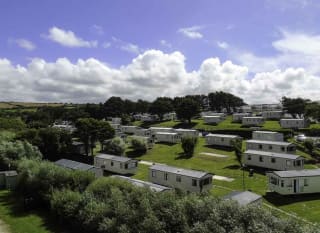
Base your adventure at nearby St Ives Bay holiday parks for easy access to trails and a relaxing stay after your walks.
Crazy about Cornwall’s stunning beaches, charming villages, and iconic attractions? Imagine stepping out your door and straight into all that magic! Check out our Cornwall holiday homes for sale and see how your dream escape could become your everyday reality.
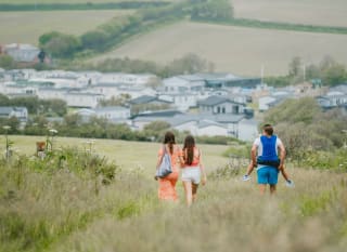
The town's fantastic coastal landscape can be discovered by car or boat, but the best way to fully experience the area's natural beauty is on foot – whether you want to walk to Carbis Bay or Penzance. That's why we've curated a guide to the most scenic walking routes around the St Ives coastline and beyond.
Explore the paths below to discover the region's striking scenery, uncovering its charms at your own pace. The nearby St Ives Bay holiday park means you have a beautiful base to rest after these long coastal walks!
Circular walk west from St Ives
Circular walk east from St Ives
St Ives to Zennor
St Ives to Penzance
St Ives to Lelant
St Ives to Carbis Bay
St Ives to Carnstabba Hill
St Ives to Knills Monument and Steeple Woods
St Ives to Rosewall Hill
St Ives to Trencrom Hill
St Ives town trail
If you're looking for a peaceful outing, this circular coastal walk from St Ives is for you! The route follows the scenic South West Coast Path towards Zennor before turning inland at the Hellesveor Cliffs and returning to St Ives.
Find out moreStarting at the Porthmeor Beach Car Park, join the coast path, keeping the sea on your right. Go past the Bowling Green, through the kissing gate at Clodgy Point, and along the path past Mans Head, following the yellow waymarks up the hill.
At Hor Point, you'll reach the Hellesveor Cliffs, marked by a National Trust sign around one mile from the start. Turn left and follow the track away from the sea. After around 300 metres, turn left over the stile and follow the path back towards St Ives, which becomes Burthallan Lane. Continue along this lane until you reach the T-junction at Alexandra Road, about half a mile from the stile.
Turn left and follow the zig-zagging road back to Porthmeor, heading towards Porthmeor Hill to return to the starting car park.
If you want a longer route, why not add a loop around the island at the end of the walk to create a figure-of-eight and take the coastal scenery differently?
Length: 3 miles
Difficulty: Easy

Rather than walking west from St Ives, why not walk east with one of the best coastal walks in St Ives? It will take you from St Ives Harbour, which is a 20-minute drive away from the St Ives Bay holiday park.
Find out moreYou'll be able to witness the town's picturesque settings past Hain Walk, Carbis Bay, The Belyars, and Porthmeor Beach, providing ample opportunities to capture stunning sea views and charming scenes.
From St Ives Harbour, head towards the Lifeboat House and follow the path beside it, keeping the sea on your left as you get to Porthminster Beach. After passing Porthminster, continue climbing up the path, crossing the railway line and a steep section before reaching Hain Walk.
Follow Hain Walk, passing the Baulking House. As you head downhill towards Carbis Bay Beach, about half a mile from the Baulking House, take the right fork in the path to head uphill and through the kissing gate. Continue until you reach the main St Ives Road, then turn right and walk for about 200 metres until you reach The Cornish Arms pub.
Cross here and turn up Higher Tregenna Road beside The Cornish Arms (not the narrow Steeple Lane). Head to St Ives School, and see Knills Steeple on your left. Continue straight past the school, through a wooden and metal gate, and down the lane past the golf course.
At the T-junction, turn right and then quickly left up Trenwith Lane, heading towards the Belyars Bowling Green. Follow this winding country lane for about half a mile, passing houses on the left. Continue past St Ives Veterinary Surgery, keeping the vets on your right as you head down to the main road.
Cross the pedestrian crossing and turn right down the hill, then quickly left to follow the road signposted to Porthmeor Beach Car Park and Tate St Ives. Follow this road as it zig-zags back towards Porthmeor, eventually heading down Porthmeor Hill to the beach and past the Tate St Ives gallery.
Turn left down Back Road West, past Porthmeor Studios and St Ives School of Painting. Opposite the St Ives School of Painting, turn into Norway Square, and zig-zag straight to the harbour.
Length: 4 miles
Difficulty: Easy

A challenging but rewarding and scenic coastal walk, this is one that you cannot miss while on your Cornish holiday! The whole walk will take three to four hours to complete. Plus, the route can be broken down into smaller sections, so you can still enjoy some breathtaking views and natural beauty in Cornwall.
Find out more
With some more stunning views of the Cornish landscape – it's a long one and part of the South West Coast Path, so some like to split it up – here is what to expect from one of the best coastal walks in St Ives.
Find out moreStarting from St Ives and heading along the coast to Bosigran Castle, this walk offers some incredible views out over the coastal landscapes. Then, turning inland it cuts across the Cornish countryside, past an iconic engine house, to reach the bustling town of Penzance on the southern coast.
Take the footpath towards the bowling green from the car park at the west end of Porthmeor Beach. After half a mile, go through the gate and continue walking in the same direction towards the bench on the headland. Then, take the path to the left of the bench, heading uphill. Cross the low wall and proceed to the next wall.
Turn right onto the coastal footpath. Follow it for about eight miles until you reach Porthmeor Cove. The path is rocky and passes very close to a gully.
After another mile, the path crosses gorse at Bosigran Castle, then joins another path leading to the headland from the main road. Take this path until you reach a gate with a stone stile. Cross it and take the path bearing right until you reach another road.
On the road, turn right. After 50 yards, take the path on the left, leading between the hills of Carn Galver and Watch Croft. Follow the path until another crosses at the hill's bottom (near a large boundary stone). Head straight on for the engine house, about half a mile away.
Just before the engine house, take the path on the right. Turn left at the engine house and walk 50 yards past the concrete gatepost. Turn right onto the track and follow it between the hedges until it becomes a road. After half a mile, it joins the road from Morvah to Penzance. Cross the stile on the left and walk along the side of the field. At the end, cross into the field and walk straight across to the stile on the far side.
Cross the stile and follow the hedged path for about a quarter of a mile until it becomes a lane. Turn right onto the road for a quarter of a mile. Past the entrance to Madron Well, cross the stile by the gate on the left. Follow the path between the hedges, then along the edge of two fields, until another stile leads to the main road through Madron. Walk through the village and take the lane on the right just before the pub, which leads to the church and the car park.
Take the path between the trees. This follows the left-hand side of the first field, the middle of the next, leading to the road at the bottom of the hill. Cross the road and the stile opposite. Follow the path across the field and through the gate. Follow the farm track in the same direction through another gate. Head for the far left-hand corner of the field, then cross the stile, heading for the farmhouse.
Go through the gate, then past the farmhouse and up the lane until you reach the Penzance bypass. Go straight across and follow the lane opposite until it joins the busy road next to the auction house. Turn left - Penzance town centre is half a mile down this road.
Length: 14.9 miles
Difficulty: Challenging

If you're after one of the prettiest coastal walks in St Ives, why not try another one on the South West Coast Path?
Find out moreFrom St Ives Station, take the path heading down to Porthminster Beach, a 15-minute drive from the nearby holiday park. Turn right to pick up the South West Coast Path and follow it above the beach all the way to the National Trust land at Porthminster Point. Cross the railway line on the footbridge and head up the steep path, turning left at the top. Pass the black-and-white Baulking House and continue on the tarmac path towards Carbis Bay.
As you approach Carbis Bay beach, cross the railway bridge and head down the path towards it. Before reaching the beach, bear left to go behind the car park and continue up Beach Road. Pick up the Coast Path again to the left at the top of the hill and go down the steps to follow the footpath around Carrack Gladden. The path will approach the railway line above Porthkidney Sands. Continue along the Coast Path above the beach, winding through the dunes.
Towards the end of the dunes, cross the railway on the footbridge and follow the path up through the golf course to St Uny's Church. Stay on the marked path and be mindful of any golf balls. Carry along the path through the churchyard, bearing left at the gate to follow the road downhill towards the railway, passing the old station house, until you reach the station.

This shorter walk is a great way to spend a part of your holiday day out! This gentle stroll is one you can do with the whole family, plus you can catch some stunning views over St Ives Bay…
Find out moreFrom St Ives Station, take the path heading down to Porthminster Beach. Turn right to pick up the South West Coast Path and follow it above the beach to the National Trust land at Porthminster Point.
At Porthminster Point, cross the railway line on the footbridge and head up the steep path, turning left at the top. Pass the black-and-white Baulking House, the huer's hut, and continue up the tarmac toward Carbis Bay. As you approach Carbis Bay beach, cross the railway bridge and head down the path towards the beach. From here, walk up to the Carbis Bay train station.
Length: 1.2 miles
Difficulty: Easy

Another simple walk will prepare you for those longer Cornish coastal walks in St Ives, so why not add it to your holiday itinerary?
Find out moreWalk up The Stennack from town right to the crossroads by the roundhouse and Tom's yard. Be careful here as you walk along the road to Halsetown Inn. Go through the gate on the left of the Inn and follow the path up the hill to catch some stunning views.
Length: 1.5 miles
Difficulty: Easy

If you like your scenic locations full of quirky history, this is the walk for you! Knills Monument is a 50ft tall granite obelisk high up on Worvas Hill in Steeple Woods, which was commissioned in 1782 by eccentric local mayor John Knill, who intended it to become his mausoleum.
Find out moreSo, remember your cameras for this walk to capture the historic monument and the natural beauty!
Leaving St Ives, take the main road towards Carbis Bay. After passing The Cornish Arms pub, turn right and follow the left fork up the road. At the top of the road, you'll see an information board and signposts. Turn left here and follow the path up to Knills Monument.
You'll then climb Worvas Hill, and the land below it is the Steeple Fields Nature Reserve. To the right, you'll find the Steeple Woods, which are lovely to walk through (especially if you're bringing your dog along), but do take care here as there are some old mine shafts in the area.
Length: 2 miles (also depends on your route at the top)
Difficulty: Easy/moderate

Many prefer to drive to Rosewall from St Ives, but walking is worth it to catch the views! Here's one of the ways to experience this stunning walk…
Find out moreStarting at Consols, well known for its mill pond, follow Towednack Lane for about a mile. The footpath across the fields is marked. As you climb, turn around and take in the views of St Michael's Mount and the entire southern coast of West Penwith.
As the path starts descending the northern side of Rosewall Hill, the views over St Ives become more prominent, extending to Portreath in the distance.
Continuing onwards, you'll cross the B3306 at a parking bay, which can help you approach the walk from a different direction. After crossing the main road, it's a short climb up to the top of Trevalgan Hill, offering far-reaching views over the north coast from Clodgy Point at the western end of St Ives towards and beyond Zennor Head.
At the Trevalgan campsite, pick up the old church path and pass through Trowan before turning up the lane to the Hellesveor site. Cross the road back to the Consols pond to complete the circuit.
Length: 4 miles
Difficulty: Moderate

This National Trust trail involves climbing to the top of 175m-high Trencrom Hill for far-reaching views. It offers a glimpse of prehistoric archaeology and history and the chance to spot wildlife along the way, so what about trying this coastal walk in St Ives?
Find out moreStarting from the Trencrom Hill car park, head west towards Badger's Croft, following the track. Then, take the path on the right, skirting around the hill.
Climb to the top of Trencrom Hill from the northern side. Once at the summit, take in the views stretching across North Cornwall towards Godrevy and Rosewall Hill to the west.
Follow the track as it winds back down and around, returning to the car park. Along the way, you may see traces of the area's mining history.
Length: 1 mile
Difficulty: Moderate

What better way to experience the whole of St Ives than a walk around it all? This surely makes it one of the best coastal walks in St Ives…
Find out moreComing out of the St Ives Station car park, walk along The Warren heading towards the town. Continue along The Warren as it rounds Pedn-Olva and turns into Pendola Walk and Market Strand.
From the lifeboat station, continue along Wharf Road. At the slipway, continue above the beach, following Back Lane, The Wharf, and Quay Street towards Smeaton's Pier and New Pier. Walk on past the museum.
Passing above Porthgwidden Beach, follow the South West Coast Path around the Island. Shortly detour to St Nicholas Chapel, carry on around the Island, then turn right on Porthmeor Road beyond.
Turn right onto Back Road East and then Back Road West. At the top, turn left following the 'Access to Fore Street only' sign along The Digey. Turn right on Fore Street, bearing left when it forks. At the end, walk past the Market House to the Parish Church.
Continue along St Andrew's Street and then up Skidden Hill to the main road at the top. Turn left on the main road, turning left again beyond to return to The Warren and the station.
Length: 1.9 miles
Difficulty: Easy
There are so many contenders for the best coastal walk in Cornwall. Here are just a few of the options you can incorporate into your next Cornish holiday:
St Ives town trail
The Lizard Peninsula
St Ives to Knills Monument and Steeple Woods
St Ives to Zennor
St Ives to Lelant
St Ives to Trencrom Hill
St Ives to Carbis Bay
Sandymouth to Duckpool
St Ives to Penzance
St Ives to Rosewall Hill
When you embark on one of these walks, remember to tell someone your plans and pack appropriate walking gear, clothing, and water.
With these tips and top walks to try out, you can have the most adventurous holiday with these coastal walks in St Ives. So why book your next holiday today?
Hampshire | Scotland | Isle of Wight | Dorset | North Wales | Yorkshire | Lincolnshire | Cornwall
Leading a dedicated on-site team for the past 4 years, he focuses on delivering exceptional guest experiences at one of the UK's most iconic seaside locations. Nathan contributes expert travel and destination content for Away Resorts, drawing on deep local knowledge of Cornwall's standout attractions, from the St Ives to St Erth scenic railway and St Ives harbour to Land's End, St Michael's Mount, and Kynance Cove on the Lizard Peninsula.
Follow Nathan Roots for thoughtful takes, fresh ideas, and inspiring reads.
Whilst you wait... just think about being in your swimmers, the sun's out and the smiles are big
Enter your details to make a payment or request a change
Don't remember your details? Check your confirmation email, or speak to our team
Are you an owner with us? Click here to login